Geolocating a photo involves pinpointing the exact geographical location where it was taken, and at dfphoto.net, we’re dedicated to helping you master this skill. This guide will walk you through techniques to identify locations from images, offering valuable insights for photographers, journalists, and anyone interested in open-source intelligence. Discover the art of image verification and location identification today. This process enhances digital investigation, geospatial analysis, and location intelligence.
1. What Is Geolocation and Why Does It Matter?
Geolocation is the process of determining the precise geographic location of an object or event. For photos and videos, this means finding the exact spot on Earth where they were captured. Think of it as digital detective work, using visual clues and mapping tools to uncover hidden locations. This is a critical skill for confirming the authenticity of images and understanding the context behind them.
-
Why is it important? Geolocation plays a vital role in verifying information, especially in journalism and open-source intelligence. Knowing the when and where of an event can confirm its validity and provide crucial context.
-
Real-world applications: Imagine tracking military conflicts, identifying criminal movements, or verifying the location of a news event. Geolocation makes all of this possible.
-
Coordinate systems: Latitude and longitude coordinates divide the Earth into a grid, allowing us to pinpoint any location with accuracy.
- Degrees/minutes: 52°31.86797’ N, 013°24.03009’ W
- Degrees/minutes/seconds: 52°31’52.0784” N, 013°24’01.8054” W
- Decimal: 52.5311329 lat, -13.4005015 long.
-
Mapping tools: We’ll primarily focus on using free online maps to accurately locate images, turning you into a geolocation expert.
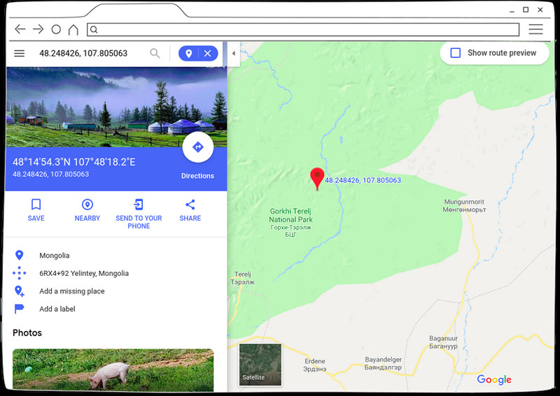 Example of latitude and longitude in Google Maps
2. What Mapping Services Can I Use To Geolocate?
Many sites offer mapping services. They can help identify and verify image details. These services provide detailed imagery of the globe, each with its strengths and weaknesses. Choosing the right one, or combining several, can significantly improve your geolocation accuracy.
- OpenStreetMap (OSM): A collaborative, open-source mapping project with a large community of contributors. OSM is ideal for detailed local information and is used as the base for many other mapping projects.
- Google Maps: Offers satellite imagery, street view, and a wealth of location data. Google Maps is a powerful tool for identifying landmarks and verifying details.
- Satellites.pro: Aggregates multiple mapping service providers, including Apple Maps, OpenStreetMap, Yandex Maps, and Google Maps. It also provides local names of neighborhoods, villages, and towns, which can be helpful for identifying locations in different languages.
- World Imagery Wayback: A free photo archive provided by ESRI, offering historical imagery that can be useful for tracking changes over time.
- Sentinel: Offers lower resolution satellite imagery. While not as detailed as other options, it can be useful for broad area analysis.
3. How Does Image Resolution Impact Geolocation Accuracy?
Image resolution is very important for accurate geolocation. Specialized companies launch satellites that capture images of the world. Image quality and detail vary among companies, as does how often their satellites circle the Earth to take pictures of the same place. This competition gives us multiple high-resolution images for most places on Earth.
- Availability Limitations: Access to high-resolution images is restricted due to legal and censorship reasons.
- Reasons for limitations: Security restrictions around army locations in war zones, government censorship, lack of transparency in occupied territories, state interventions to blur details of strategic locations, economic locations, events, and natural reserves with endangered species.
4. What Is The Best Approach To Determine Geographic Location?
Every geolocation case is unique, and you may need different methods and tools. Each attempt to geolocate an image is like solving a puzzle. The solution relies on having a strategic mindset, and the right toolkit.
5. What Are The Four Key Elements Of Geolocating An Image?
The philosophy of identifying a photo or video’s geographic location is based on these elements:
- Collect information
- Process information
- Search
- Check result
6. How Do I Collect Information From An Image?
The information collection phase involves listing everything visible in the image, no matter how small. This is a visual sweep of the data. You should also gather any available details about the image, such as the event it depicts, its context, when it occurred, and any related comments.
7. What Does Processing Information Involve?
The processing phase involves organizing and classifying the information you’ve collected. The goal is to determine where to begin your search.
- Example: Imagine you identify a store name and a car license plate in the image. You should prioritize the store name because fixed locations are more likely to remain unchanged, unlike a car.
8. How Do I Search For Information Effectively?
The search phase is where you put your processed information to work. Using the store name as a starting point, you can search online or use reverse image searches.
- Reverse Image Search: Use the entire image, or zoom in on the store using reverse image searches.
- Corroboration: Compare your search results with the original image to confirm any potential matches.
9. How Do I Check The Results Of My Search?
The check phase involves verifying whether your search findings are positive or negative. If there is a match, you have successfully geolocated the image.
- Verification: Compare the images from your search with the information from the initial collection phase.
- Negative Result: If the findings don’t match, repeat the four steps, searching elsewhere or using different tools.
- Second Attempt: Use previous results to guide your next steps. For example, if the store has multiple locations, use the car plate to identify the country, town, or province where it’s registered.
10. What Happens If I Get Conflicting Information?
Cars can travel anywhere, so a license plate from one location doesn’t guarantee the image was taken there. However, it’s still a valuable clue. Success in geolocation depends on your ability to gather a lot of information. You also need patience during your searches.
11. Case Study 1: How Do I Geolocate A Photo Of A Hospital Fire?
Let’s start with the information gathering stage. We’ll focus on what’s visible in the image without searching for external context.
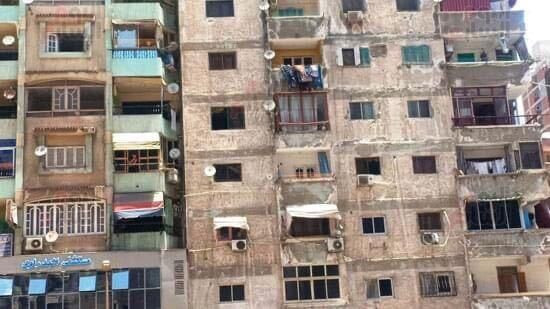 Badrawy Hospital 2 Fire
- Key Elements:
- Two buildings of different colors
- Air conditioners and shower trays
- A sign for Badrawy Hospital
- Processing the Information: The hospital name is the most important clue.
- Research: Using Google Maps, search for “Badrawy Hospital.”
- Initial Result: Google Maps shows Badrawy Hospital in Smouha, Alexandria, Egypt.
- Checking the Results: Compare Google Maps images of the hospital’s front with the original image.
- Negative Match: The photos are completely different.
12. What Do I Do If My Initial Search Fails?
If the first attempt fails, repeat the search and look for new images. Since there are multiple options for this hospital, try searching for “Badrawy Hospital 2 branch.”
- New Location: The search reveals Badrawy Hospital 2 in Sidi Beshr, Alexandria, Egypt. Google Maps doesn’t have pictures of this branch.
13. How Can I Use Google Street View To Verify A Location?
Google Street View provides 360-degree images taken by Google vehicles or user uploads. This allows you to virtually explore the location.
- Using Street View: Drag the “yellow man” icon to the area in front of Badrawy Hospital 2.
- Adjusting Coordinates: If the initial position isn’t accurate, move the yellow man until you find the correct spot.
- Finding the Match: Look for the hospital’s facade.
14. How Do I Know When I’ve Found The Right Location?
When you find a Street View image that matches the original photo, you’ve successfully geolocated the image.
- Contextual Search: Searching online for “Badrawy Hospital 2” reveals news articles about a fire in June 2020, confirming the location.
15. How Can Reverse Image Search Help In Geolocation?
Reverse image search is a powerful tool for finding the context of an image. It allows you to search using the image itself, rather than keywords.
- Accessing Reverse Image Search: Go to Google Images and click the camera icon in the search bar.
- Google Lens: Upload the image to Google Lens, which recognizes elements like text, faces, and buildings.
- Finding the Source: If initial results are negative, click “find images source.”
- Confirming Details: In this case, the search leads to an article in Al-Youm Al-Sabea newspaper, which published the same photo from the scene of the accident. The article provides enough details to confirm the location.
 Screenshot from Google
16. Case Study 2: How Do I Verify The Location Of Military Vehicles?
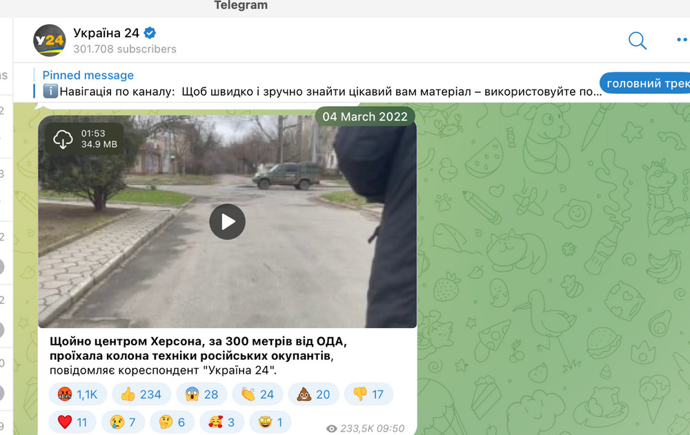
In June 2020, a video surfaced on Facebook showing Egyptian military vehicles on a highway. The accompanying comments claimed the vehicles were heading to Tobruk, Libya. Let’s verify this claim by geolocating the video.
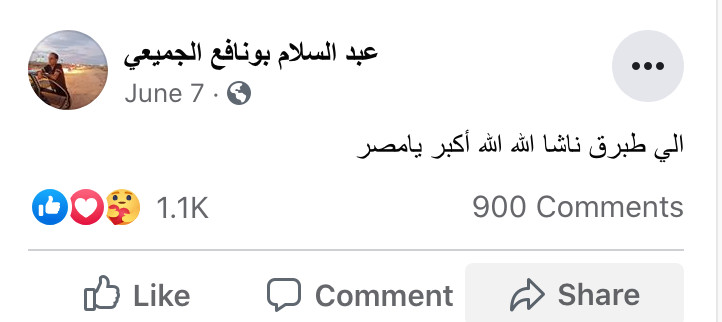 Egyptian military vehicles
- Information Collection:
- Egyptian military vehicles
- Highway setting
- A blue gas station
- A Toyota car
- Processing the Information: The gas station is the best starting point due to its distinctive sign and static location.
- Research: The video quality makes it difficult to identify the station’s name. Search Google Maps for “Egypt gas station” or “Egypt gas.”
- Finding a Match: The search reveals the Al Taawun gas station, CO-OP Egyptian, with a similar blue logo.
17. How Do I Start My Map Search?
Begin by searching for Al-Taawun gas stations along the highway in northwest Egypt, which connects to Tobruk, Libya.
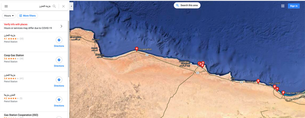 Google Maps
- Reviewing Results: The search returns about 12 results along the western coastal road connecting Egypt and Libya.
- Looking for Specific Signs: Identify the buildings and vacant land around the station.
18. What Specific Details Should I Look For In The Images?
Look for a building before the gas station and another under construction after it, with vacant land nearby.
- Verifying Results: One result near Ras Hajjaj matches these specifications.
19. How Do I Verify If I’ve Found The Correct Gas Station?
Using Google Images, find a photo of the station that matches the details you’re looking for. In this case, a photo of a station near the village of Ras Hajjaj fits the criteria.
- Confirmation: The gas station is about 250 kilometers from the Libyan-Egyptian border. This contradicts the claim that the equipment is in Libya or Tobruk.
20. Case Study 3: How Do I Geolocate A Video From A Conflict Zone?
During Russia’s invasion of Ukraine, a video dated March 4, 2022, claimed that Russian forces were advancing into the center of Kherson, just 300 meters from the city’s central administration building. Let’s verify this.
 Telegram channel ukraina24tv
- Information Gathering:
- Military vehicles with the letter Z
- A perpendicular intersection
- Pavement with a walkway, trees, and asphalt
- Buildings with triangular roofs
- The video was filmed in Kherson
- Filming location is within 300 meters of the central administration building.
21. How Do I Proceed When There Are No Obvious Landmarks?
In this case, there are no prominent landmarks to aid the search. So, draw the video plan from an overhead perspective. Convert what the videographer sees into a bird’s-eye view, similar to what you see on maps. Draw a large circle around the building and begin the search process.
- What to Look For:
- Crossroads
- Sidewalks with a green area
- Buildings with triangular roofs
- Tall buildings after the shorter buildings with triangular roofs.
22. How Do I Find The Location On The Map?
Search for areas that match the criteria. This requires time and careful consideration of all elements. Search duration varies, but it relies on patience and attention to detail. During this search, you’ll find a strong similarity in the area around these coordinates: 46.64468827846318, 32.61594308344351
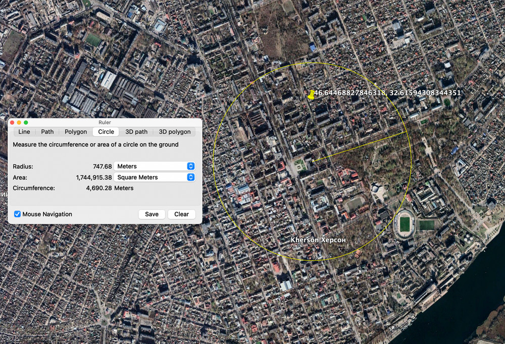 Screenshot from Google Maps.
23. How Do I Confirm The Location?
Match the details of the video to the location you’ve found. Look for pictures of a government building on the opposite intersection. Use Google Maps to find photos taken from the same street.
- Final Confirmation: Our geolocation efforts confirm that Russian military equipment likely approached Kherson city center on March 4, 2022.
24. What Are The Key Resources For Further Learning?
There are several excellent resources that can help you improve your geolocation skills.
- Articles and Guides:
- First Draft News: Offers guides on verification techniques.
- Bellingcat’s Online Investigation Toolkit: Provides tools and techniques for open-source investigation.
25. Conclusion: Mastering The Art Of Geolocation
You now have a detailed introduction to geolocation using free online maps and other image verification tools. This article provides a simplified methodology for tracking leads from images, achieving accurate location results, and confirming or refuting claims. Remember that methods and solutions vary based on your team’s skills. However, the way of thinking and going through this process remains similar and repeatable in any context. Determining a geographic location can take minutes or hours. You can benefit from a team effort to confirm details and find a solution. Combining several search methods, like reverse image search with geolocation and historical satellite images, verifies information, helps draw timelines of events, and understand the development of a context.
According to research from the Santa Fe University of Art and Design’s Photography Department, in July 2025, understanding geolocation will be essential for journalism.
26. Discover More At Dfphoto.Net
Eager to enhance your photography skills and uncover the stories behind the images? Visit dfphoto.net for tutorials, stunning photo collections, and a vibrant community of photographers. Explore new techniques, find inspiration, and connect with fellow enthusiasts.
- Address: 1600 St Michael’s Dr, Santa Fe, NM 87505, United States
- Phone: +1 (505) 471-6001
- Website: dfphoto.net
27. Frequently Asked Questions (FAQ) About Geolocation
- What is geolocation? Geolocation is identifying a photo or video’s exact geographic location on the Earth’s surface.
- Why is geolocation important? Geolocation helps verify information, track events, and provide context to visual media.
- What tools can I use for geolocation? Google Maps, OpenStreetMap, Satellites.pro, and reverse image search engines are some useful tools.
- How do I start geolocating a photo? Begin by collecting all visible information from the image, like landmarks, signs, and unique features.
- What is reverse image search? Reverse image search is a technique where you search using an image instead of text to find its source and related information.
- How do I use Google Street View for geolocation? Drag the “yellow man” icon from Google Maps to the location you suspect, and explore the 360-degree view to match visual details with the image.
- What if I can’t find any obvious landmarks? Draw a video plan from an overhead perspective and search for patterns like crossroads, sidewalks, and unique buildings.
- What if my initial search is unsuccessful? Repeat the process with different search terms, mapping services, and details from the image.
- Can geolocation be used for journalism? Yes, geolocation is crucial for verifying news, tracking events, and providing accurate context in journalistic investigations.
- How long does it take to geolocate an image? Geolocation can take minutes or hours, depending on the complexity of the image and the available information.
