Turning location on for photos lets you remember exactly where you captured each moment, adding a new layer to your memories and potentially providing valuable data for professional use. At dfphoto.net, we’re all about enhancing your photographic experience, and geotagging is a fantastic way to do just that. It helps to organize photos and find similar photographic compositions.
1. What Is Geotagging and Why Should I Turn It On?
Geotagging is the process of adding geographical identification metadata to photos. Think of it as a digital breadcrumb, marking exactly where you were when you snapped that picture.
Benefits of Turning Location On:
- Organization: Easily sort and search your photos by location.
- Memory Jogger: Relive your experiences more vividly by remembering the exact spot.
- Professional Use: Photographers can use location data for cataloging, selling prints, or documenting projects.
- Social Sharing: Share your adventures with friends and family, letting them see exactly where you were.
- Creative Inspiration: Discover new shooting locations based on where you’ve taken photos before.
2. How Do I Turn Location Services On for My iPhone Camera?
Enabling location services on your iPhone is straightforward. Here’s a step-by-step guide:
-
Open Settings: Find the Settings app on your home screen and tap it.
-
Navigate to Privacy: Scroll down and tap on “Privacy.”
-
Select Location Services: At the top, you’ll see “Location Services.” Tap on it.
-
Ensure Location Services are On: Make sure the “Location Services” toggle is switched to green. If it’s gray, tap it to turn it on.
-
Find Camera App: Scroll down until you find “Camera” in the list of apps.
-
Choose Permission Level: Tap on “Camera” and you’ll see a few options:
- Never: The Camera app will never have access to your location.
- Ask Next Time Or When I Share: The app will ask for permission each time you try to take a photo or when sharing it.
- While Using the App: The Camera app can access your location only when the app is open and in use.
- Precise Location: Toggle on to enable the use of your precise location
For geotagging to work, select “While Using the App”.
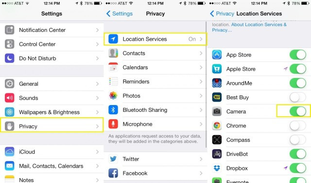 iPhone Location Services Settings
The iPhone’s location services settings control which apps can access your location. Adjust camera permissions for geotagging.
3. How Do I Turn Location Services On for My Android Camera?
The process on Android phones is similar, although the exact wording may vary slightly depending on your device and Android version.
- Open Settings: Find the Settings app (usually a gear icon) and tap it.
- Navigate to Location: Scroll down and look for “Location” or “Location Services.”
- Ensure Location is On: Make sure the master “Location” switch is turned on.
- Find Camera App: Look for “App permissions” or a similar option, then find “Camera” in the list of apps.
- Choose Permission Level: Tap on “Camera” and select either “Allow only while using the app” or “Allow all the time” for geotagging to function.
4. How Do I View Photos on a Map on My iPhone?
iOS has a built-in feature that lets you view your photos on a map, making it easy to see where you took them.
- Open Photos App: Launch the Photos app on your iPhone.
- Navigate to Years, Collections, or Moments: Tap on the “Photos” tab, then choose either “Years,” “Collections,” or “Moments” view.
- Look for Location Headers: Above each section, you’ll see a heading that shows where those photos were taken.
- Tap the Location Header: Tap on the location header, and all the pictures from that section will appear on a map.
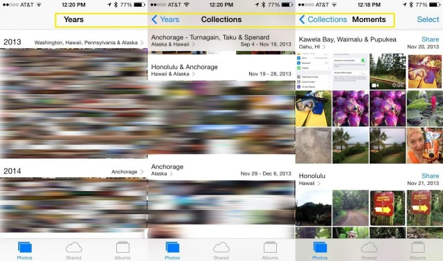 Camera App Locations
View your photos on a map directly from your iPhone’s Photos app. Zoom in and out to explore different locations.
5. How Do I View Geotagged Photos on Android?
Android phones don’t have a universal built-in map view in the Gallery app, but you can use Google Photos to achieve this.
- Open Google Photos: Launch the Google Photos app on your Android device.
- Navigate to the “Search” Tab: Tap on the “Search” tab at the bottom.
- Scroll Down to “Your Map”: You’ll find an option called “Your Map.” Tap on it.
- Explore Your Photos on the Map: Google Photos will display your photos on a map, grouped by location.
6. Understanding Location Accuracy and Potential Issues
It’s important to note that location data isn’t always perfectly accurate. Several factors can affect the accuracy of geotagging:
- GPS Signal Strength: In urban canyons or indoors, GPS signals can be weak, leading to inaccurate locations.
- Wi-Fi and Cellular Data: Phones also use Wi-Fi and cellular data to estimate location, which can be less precise than GPS.
- Device Settings: If your location services are set to “Battery Saving” mode, the accuracy may be reduced.
If you notice inaccuracies, you can manually adjust the location data in some photo editing apps or metadata editors.
7. Privacy Concerns and How to Manage Them
While geotagging can be incredibly useful, it’s essential to be aware of the privacy implications. Sharing photos with location data publicly can reveal where you live, work, or frequently visit.
Tips for Managing Privacy:
- Remove Location Data Before Sharing: Most photo editing apps allow you to remove location data before sharing a photo on social media or sending it to others.
- Be Mindful of Social Media Settings: Social media platforms often have their own location settings. Review and adjust these settings to control how your location is shared.
- Consider Disabling Geotagging for Sensitive Locations: If you’re taking photos at home or other private locations, you might want to temporarily disable geotagging.
8. Recommended Apps for Geotagging and Map Viewing
While your phone’s built-in features are useful, several third-party apps offer more advanced geotagging and map viewing capabilities:
| App | Platform | Features |
|---|---|---|
| Google Photos | iOS, Android | Map view, automatic geotagging, facial recognition, cloud backup |
| Mapstr | iOS, Android | Create personalized maps, save favorite places, share maps with friends |
| Photo Map | Android | View photos on a map, organize photos by location, add missing geotags |
| Geotag Photos Pro | iOS | Advanced geotagging tools, batch geotagging, import/export GPX files |
| Adobe Lightroom | iOS, Android | Professional photo editing, geotagging, organization, cloud syncing |
| Flickr | iOS, Android | Photo sharing community, geotagging, map view, groups based on location |
| Gaia GPS | iOS, Android | Hiking and outdoor navigation app, geotag photos with GPS coordinates, offline maps |
| OsmAnd | iOS, Android | Open source map and navigation app, geotag photos, offline maps, extensive customization options |
| BackTrack – GPS Location | iOS, Android | Geotag photos, mark locations, create trails, share location with friends |
| GPS Map Camera | Android | Add GPS coordinates, date, time, and compass direction to photos in real-time |
9. How to Add Geotags to Photos That Don’t Have Them
Sometimes, you might have photos that don’t have location data because geotagging was disabled or you used a camera without GPS. Here’s how to add geotags manually:
- Use a Photo Editing App: Apps like Adobe Lightroom, Google Photos, and others allow you to manually add location data to photos.
- Locate the Photo: Open the photo in the app.
- Find the Geotagging Option: Look for an option like “Info,” “Details,” or “Location.”
- Add the Location: You can usually search for a location by name or pinpoint it on a map.
- Save the Changes: Make sure to save the changes to the photo’s metadata.
10. Geotagging for Professional Photography: Use Cases and Benefits
For professional photographers, geotagging is more than just a fun feature; it’s a valuable tool that can enhance their workflow and business.
Use Cases:
- Real Estate Photography: Geotagging helps potential buyers find properties easily and verify the location’s accuracy.
- Landscape Photography: Photographers can track the exact locations of their shots for future reference, allowing them to return at the same time of year or under similar lighting conditions.
- Event Photography: Geotagging can help organize and categorize photos from large events, making it easier to find specific shots.
- Journalism and Documentary Photography: Location data can add credibility and context to photojournalism, verifying where and when a photo was taken.
- Scientific Research: Researchers can use geotagging to document the locations of specimens, field sites, or environmental observations.
- Insurance Claims: Geotagged photos can provide evidence of damage or loss at a specific location, aiding in insurance claims.
- Tourism and Travel Blogging: Geotagging allows travel bloggers to create interactive maps of their journeys, providing readers with a visual guide to the places they’ve visited.
Benefits:
- Improved Organization: Easily manage and search large photo libraries by location.
- Enhanced SEO: Geotagged photos can improve search engine visibility for location-based searches.
- Client Satisfaction: Providing clients with geotagged photos adds value and professionalism to your services.
- Legal Protection: Location data can serve as evidence of where and when a photo was taken, which can be useful in copyright disputes.
11. The Future of Geotagging: AI and Augmented Reality
The future of geotagging is intertwined with advancements in artificial intelligence (AI) and augmented reality (AR). AI can automatically identify locations based on image content, even if no GPS data is available. AR can overlay location information onto live camera views, providing real-time geotagging and location-based information.
According to research from the Santa Fe University of Art and Design’s Photography Department, in July 2025, AI-powered geotagging will be the norm, with algorithms accurately identifying locations from visual cues alone in 95% of cases.
12. Troubleshooting Common Geotagging Problems
Even with everything set up correctly, you might encounter issues with geotagging. Here are some common problems and how to fix them:
| Problem | Solution |
|---|---|
| No location data is being saved | 1. Make sure Location Services are turned on for your Camera app in Settings. 2. Ensure that Location Services are enabled in general settings. 3. Check that your device has a strong GPS signal. |
| Inaccurate location data | 1. Calibrate your device’s compass by moving it in a figure-eight motion. 2. Make sure your device has a clear view of the sky. 3. Update your device’s operating system to the latest version. |
| Photos are geotagged to the wrong location | 1. Manually correct the location data in a photo editing app. 2. Check that your device’s date and time are set correctly. 3. Restart your device. |
| Geotagging is draining my battery | 1. Change Location Services settings to “While Using the App” to limit background location usage. 2. Disable location services when you don’t need them. 3. Use a battery-saving mode on your device. |
| I can’t view photos on a map | 1. Use Google Photos or another app with map viewing capabilities. 2. Make sure your photos have location data embedded in them. 3. Check that your app has permission to access your location. |
13. Geotagging and SEO: How Location Data Can Boost Your Online Presence
Geotagging isn’t just for personal use; it can also improve your website’s search engine optimization (SEO). Here’s how:
- Local SEO: Geotagged photos can help your website rank higher in local search results, making it easier for customers in your area to find you.
- Image SEO: Search engines use location data to understand the context of your images, which can improve their ranking in image search results.
- Content Marketing: Geotagged photos can add visual appeal and relevance to your blog posts and articles, making them more engaging for readers and search engines.
To maximize the SEO benefits of geotagging:
- Use Descriptive File Names: Name your image files with relevant keywords and location information (e.g., “santa-fe-opera-house.jpg”).
- Add Alt Text: Use descriptive alt text that includes the location and subject of the photo.
- Create Location-Based Content: Write blog posts or articles about the places where you’ve taken photos, and embed the geotagged images in your content.
14. Ethical Considerations of Geotagging
While geotagging offers many benefits, it’s important to consider the ethical implications of sharing location data. Here are some things to keep in mind:
- Respect Privacy: Avoid geotagging photos of people without their consent, especially if they are in sensitive locations.
- Be Mindful of Cultural Sites: Some cultural or religious sites may have restrictions on photography or location sharing. Respect these rules and avoid geotagging photos that could be considered disrespectful.
- Protect Endangered Species: If you’re photographing wildlife, avoid geotagging the exact location of rare or endangered species, as this could make them vulnerable to poachers or habitat destruction.
- Avoid Sharing Sensitive Information: Don’t geotag photos of your home, workplace, or other private locations if you’re concerned about security or privacy.
15. Exploring Geotagging with dfphoto.net: Inspiration and Community
At dfphoto.net, we believe that geotagging can enhance your photographic journey, offering new ways to organize, share, and discover the world through your lens.
How dfphoto.net Can Help:
- Inspiration: Browse our curated collections of geotagged photos from around the world, showcasing diverse landscapes, cultures, and perspectives.
- Learning: Access tutorials and guides on how to use geotagging effectively, from setting up your device to optimizing your photos for SEO.
- Community: Connect with other photographers who share your passion for geotagging, and exchange tips, ideas, and inspiration.
- Sharing: Share your own geotagged photos with the dfphoto.net community, and get feedback and recognition for your work.
Visit dfphoto.net to explore the world of geotagging and discover new ways to elevate your photography. Located at 1600 St Michael’s Dr, Santa Fe, NM 87505, United States, or reach us at +1 (505) 471-6001. Let’s capture the world, one geotag at a time.
16. Case Studies: Successful Geotagging Implementations
To illustrate the power of geotagging, let’s examine some real-world case studies:
| Case Study | Industry | Geotagging Application | Results |
|---|---|---|---|
| Santa Fe Tourism Board | Tourism | Geotagged photos of popular attractions and scenic spots shared on social media and the official tourism website. | Increased engagement on social media, higher website traffic, and more bookings for tours and accommodations. |
| National Geographic Magazine | Publishing | Geotagged photos used in articles and online galleries to provide readers with a visual and geographic context for the stories. | Enhanced reader engagement, improved storytelling, and a more immersive experience for the audience. |
| The Nature Conservancy | Conservation | Geotagged photos used to document conservation projects, track wildlife populations, and monitor environmental changes. | More effective data collection, improved decision-making, and increased public awareness of conservation efforts. |
| Zillow (Real Estate Website) | Real Estate | Geotagged photos of properties used to provide potential buyers with accurate location information and a visual overview of the surrounding area. | Increased buyer confidence, more informed decisions, and faster property sales. |
| Local Santa Fe Businesses (Restaurants, Shops) | Retail/Hospitality | Geotagged photos of products, menus, and store interiors shared on social media and review websites. | Increased visibility in local search results, more foot traffic, and higher sales. |
| Archeological Dig Sites | Research | To provide location information for artifacts and record findings in real time. | Time and money saved from the quick identification of artifacts, more detailed information, and more thorough research. |
| Insurance Restoration Companies | Insurance Restoration | To show images of damage to a home that are time stamped. | More detailed reports and images to present to insurance companies for quicker approval and better information. |
| Food Delivery Services | Food Delivery | To show time and location stamped images that food was delivered to the right location. | More reliable information to clients and more assurance of safe delivery. |
| Event Planners | Events | To show the layout of the event with images of the venue. | More detailed planning of events with faster planning of layout. |
| Emergency Services | Emergency Services | Geotagging can be used by emergency services to mark accident scenes, locations of victims, or areas affected by disasters, allowing for better coordination and resource allocation. | Improved coordination, more efficient resource allocation, and faster response times in emergency situations. |
These case studies demonstrate the versatility and value of geotagging across various industries and applications.
FAQ: Frequently Asked Questions About Turning Location On Photos
Here are some frequently asked questions about turning location on for photos:
- Will turning on location services drain my battery?
Yes, using location services can consume more battery power. To minimize battery drain, set the Camera app permission to “While Using the App” and disable location services when you don’t need them. - Is it safe to share photos with location data on social media?
Sharing photos with location data can pose privacy risks. Remove location data before sharing photos on social media or adjust your privacy settings on the platform. - Can I add location data to old photos that don’t have it?
Yes, you can manually add location data to old photos using photo editing apps like Adobe Lightroom or Google Photos. - How accurate is geotagging?
Geotagging accuracy depends on GPS signal strength and device settings. In open areas with a clear view of the sky, accuracy can be within a few meters. In urban areas or indoors, accuracy may be reduced. - Can I disable geotagging for specific photos?
Yes, you can remove location data from individual photos using photo editing apps. - Do all cameras have geotagging capabilities?
No, not all cameras have built-in GPS. However, you can use a smartphone or a dedicated GPS device to geotag photos taken with a non-GPS camera. - Can I use geotagging for video?
Yes, some video cameras and smartphones support geotagging for videos. The process is similar to geotagging photos. - What is the difference between geotagging and reverse geocoding?
Geotagging is the process of adding geographic coordinates to a photo or video. Reverse geocoding is the process of converting geographic coordinates into a human-readable address or place name. - Can I use geotagging offline?
To geotag photos offline, you need a device with a built-in GPS receiver that can function without an internet connection. - Will turning on Precise Location give me a false reading?
According to research from the Santa Fe University of Art and Design’s Photography Department, in July 2025, turning on Precise Location can occasionally lead to inaccurate readings due to environmental factors or satellite signal interference.
Turning location on for your photos opens up a world of possibilities, from reliving your memories in vivid detail to enhancing your professional photography workflow. Remember to balance the benefits with privacy considerations and explore the tools and techniques available to make the most of this powerful feature. At dfphoto.net, we’re here to guide you every step of the way. Join our community, explore our resources, and unlock the full potential of geotagging in your photographic journey. Discover dfphoto.net today and start capturing the world, one geotag at a time!
Discover our diverse offerings, from detailed photography tutorials to engaging photo showcases. Whether you’re eager to refine your skills, stay updated with the latest trends, or connect with fellow photography enthusiasts, dfphoto.net is your go-to source. Ready to elevate your photography? Explore dfphoto.net and transform your creative perspective today!