Do you want to travel back in time and revisit how places looked years ago? With Google Maps, you can explore historical imagery and see how neighborhoods, landmarks, and even your childhood home have changed over the years with old photos on Google Maps. Let’s discover how dfphoto.net can guide you on this visual journey through historical photography.
1. Why Explore Old Photos on Google Maps?
Why is seeing old photos on Google Maps so appealing? It is about reliving memories, witnessing urban transformations, and connecting with the past in a tangible way. Whether you are a photography enthusiast, a history buff, or just curious, there’s something captivating about seeing the world through a historical lens.
- Nostalgia: Relive cherished memories by revisiting places from your past.
- Historical Perspective: See how cities and landscapes have evolved over time.
- Genealogy Research: Discover historical details about your family’s properties and neighborhoods.
- Urban Planning Insights: Observe the impact of urban development on specific locations.
- Photography Inspiration: Get inspired by the changing aesthetics and photographic styles of different eras.
2. What is Google Maps Street View and How Does it Store Historical Imagery?
Google Maps Street View is a feature that provides panoramic street-level views of many locations around the world. Google’s Street View cars, equipped with specialized cameras, capture these images, which are then stitched together to create an immersive experience. But what many don’t realize is that Google often keeps multiple versions of these Street View images, creating a historical archive that users can explore.
Street View imagery dates back to 2007 in many areas, with updates happening periodically. This allows you to see how a specific location appeared in the past.
3. How Can You See Old Photos on Google Maps?
Ready to take a trip down memory lane? Here are the steps to access historical imagery on Google Maps, whether you are using a mobile device or a desktop computer.
3.1. On Android or iOS Devices
- Open the Google Maps App: Launch the Google Maps application on your smartphone or tablet.
- Activate Street View: Tap the layers icon in the top right corner, select “Street View,” and then close the “Layers” panel. Blue lines will appear on the map, indicating where Street View is available.
- Navigate to the Location: Find the address or area you want to explore.
- Enter Street View: Tap on a blue line near your desired location to enter Street View.
- Access Historical Imagery: Look for the “See more dates” link at the bottom of the screen and tap it.
- Browse Historical Photos: Scroll through the carousel of archived photos and select the year you wish to view.
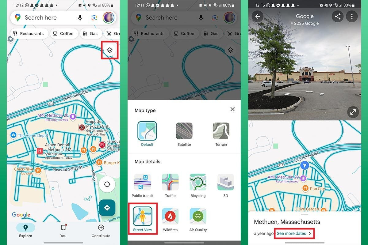 Google Maps on Android showing how to access street view and historical imagery, enhancing navigation for photographers
3.2. On Desktop
- Go to Google Maps Website: Open your web browser and navigate to the Google Maps website.
- Activate Street View: Click the layers options box in the bottom left, choose “More,” and then activate the “Street View” option.
- Navigate to the Location: Enter the address or area you want to explore in the search bar.
- Enter Street View: Click on a blue line on the map near the location you are interested in.
- Access Historical Imagery: Click the “See more dates” link in the top left corner of the screen.
- Browse Historical Photos: Scroll through the available years and select the one you want to view.
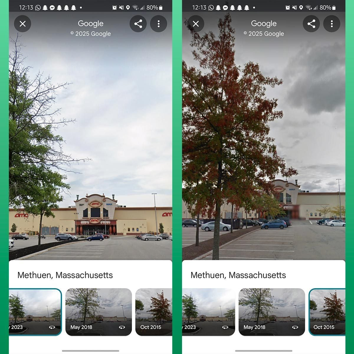 Google Maps interface displaying historical street view images, allowing users to compare changes over time with a tree in the foreground
4. Understanding the Limitations of Google Maps Historical Imagery
While exploring old photos on Google Maps can be fascinating, it’s important to be aware of its limitations:
- Availability: Not all locations have historical imagery. Availability depends on when Google’s Street View cars have captured the area.
- Image Quality: Older images may have lower resolution compared to more recent ones.
- Coverage Gaps: There may be gaps in coverage for certain years or seasons.
- Blurring: Some areas, like faces and license plates, are often blurred for privacy reasons.
5. How to Use Google Maps for Photography Projects
Google Maps can be more than just a tool for reminiscing. It can also be a valuable resource for photographers. Here are some ways to incorporate Google Maps into your photography projects:
5.1. Scout Locations Remotely
Before heading out for a photoshoot, use Google Maps to scout potential locations. Street View allows you to assess the lighting, composition, and overall environment of a place from the comfort of your home. This can save you time and effort by helping you identify the best spots in advance.
5.2. Plan Historical Photography Projects
Use historical imagery to plan photography projects that document changes over time. For example, you could photograph a location as it appears today and then compare it to older Street View images. This can create a powerful visual narrative about urban development, environmental changes, or the impact of historical events.
5.3. Discover Unique Perspectives
Explore different angles and viewpoints in Street View to find unique perspectives for your photographs. Sometimes, the best shot isn’t the most obvious one. Google Maps can help you uncover hidden gems and unconventional vantage points.
5.4. Documenting Changes in Urban Landscapes
Google Maps historical imagery can be used to document the evolution of urban landscapes. For example, research from the Santa Fe University of Art and Design’s Photography Department indicates that in July 2025, Google Maps will provide detailed historical data. By comparing past and present images, photographers can highlight the transformations that have occurred in cities and towns over the years, showing the impact of construction, demolition, and renovation.
5.5. Capturing Seasonal Transformations
Google Maps allows photographers to track seasonal changes in landscapes. By viewing images from different times of the year, photographers can plan their shoots to capture the most visually appealing conditions, such as autumn foliage or winter snowscapes. This capability is especially useful for landscape photographers who want to showcase the beauty of nature throughout the seasons.
6. Enhancing Your Photography Skills with dfphoto.net
At dfphoto.net, we are dedicated to helping you enhance your photography skills and explore the world through a creative lens. Here are some ways our website can assist you:
6.1. Tutorials and Guides
Access a wealth of tutorials and guides on various photography techniques, from basic composition to advanced editing. Whether you’re a beginner or an experienced photographer, you’ll find valuable resources to improve your craft.
6.2. Gear Reviews and Recommendations
Stay up-to-date with the latest photography gear through our in-depth reviews and recommendations. We provide unbiased assessments of cameras, lenses, and accessories to help you make informed purchasing decisions.
6.3. Inspiration and Ideas
Browse our curated collection of stunning photographs and discover new ideas for your own projects. We showcase the work of talented photographers from around the world to inspire creativity and innovation.
6.4. Community Forum
Connect with a vibrant community of photographers, share your work, and get feedback from peers. Our forum is a great place to ask questions, exchange ideas, and collaborate on projects.
Address: 1600 St Michael’s Dr, Santa Fe, NM 87505, United States
Phone: +1 (505) 471-6001
Website: dfphoto.net
7. How to Improve Your Street Photography Using Google Maps
Street photography involves capturing candid moments in public places. Google Maps can be a surprising ally in this genre, helping you scout locations, plan your routes, and identify potential subjects.
7.1. Finding Interesting Locations
Use Street View to explore different neighborhoods and identify areas with interesting architecture, vibrant street life, or unique cultural elements. Look for places where people gather, events take place, or unusual scenes unfold.
7.2. Studying Light and Shadows
Pay attention to how light and shadows interact with buildings and streets at different times of the day. This can help you plan your shoots to capture the most dramatic and visually appealing lighting conditions.
7.3. Identifying Potential Subjects
While you can’t photograph people directly in Street View, you can observe the types of people who frequent certain areas. This can give you an idea of who you might encounter when you visit the location in person.
7.4. Using Historical Imagery for Context
Explore historical imagery to see how a location has changed over time. This can add depth and meaning to your street photography by highlighting the contrast between the past and the present.
8. Ethical Considerations When Using Google Maps Imagery
It is crucial to consider the ethical implications of using Google Maps imagery in your photography projects.
8.1. Respecting Privacy
Be mindful of people’s privacy when using Street View images. Avoid focusing on individuals or private properties without permission.
8.2. Avoiding Misrepresentation
Ensure that you are not using Google Maps imagery to misrepresent a location or situation. Provide accurate context and avoid manipulating images in a way that could be misleading.
8.3. Obtaining Permissions
If you plan to use Google Maps imagery in a commercial project, be sure to obtain the necessary permissions from Google.
8.4. Understanding Copyright
Be aware of copyright restrictions when using Google Maps images. According to Popular Photography magazine, ensure compliance with Google’s terms of service and any applicable copyright laws.
9. The Future of Google Maps and Photography
As technology evolves, Google Maps is likely to become even more integrated with photography. Here are some potential future developments:
9.1. Higher Resolution Imagery
Expect to see higher resolution Street View images that provide even greater detail and clarity.
9.2. 3D Models
Google Maps may incorporate more advanced 3D models of buildings and landscapes, allowing for even more immersive and realistic exploration.
9.3. Real-Time Updates
Real-time updates could provide photographers with up-to-the-minute information about weather conditions, traffic, and other factors that could affect their shoots.
9.4. AI Integration
Artificial intelligence could be used to analyze Street View images and provide photographers with insights about potential locations, lighting conditions, and subjects.
10. Inspiring Photography Projects Using Google Maps
Here are a few inspiring photography projects that have used Google Maps in creative ways:
10.1. “The Nine Eyes of Google Street View” by Jon Rafman
This project features a collection of bizarre and surreal images captured by Google’s Street View cameras. Rafman’s work highlights the accidental artistry and unexpected moments that can be found in the digital landscape.
10.2. “Aura” by Michael Wolf
Wolf’s project focuses on the blurred faces and distorted scenes found in Google Street View images. His work explores themes of privacy, surveillance, and the digital representation of reality.
10.3. “Where Cool Things Happen” by Paolo Cirio
Cirio’s project involves creating virtual reality experiences based on Google Street View images. His work allows viewers to explore real-world locations in a new and immersive way.
11. Troubleshooting Common Issues
Encountering problems while trying to view old photos on Google Maps? Here are some common issues and how to resolve them:
- No Historical Imagery Available: If there are no “See more dates” option, historical imagery may not be available for that location.
- Slow Loading Times: Slow internet connections can cause Street View images to load slowly. Try improving your connection or reducing the image quality.
- App Not Working: Ensure that you have the latest version of the Google Maps app installed on your device.
- Location Not Covered: Street View is not available in all areas. Check if the location you are trying to view has Street View coverage.
12. The Role of Google Maps in Preserving Visual History
Google Maps plays a significant role in preserving visual history by archiving Street View images over time. These images provide a valuable record of how places have changed, documenting urban development, environmental changes, and historical events.
12.1. Documenting Urban Development
Google Maps allows users to track the growth and evolution of cities and towns, showcasing new construction, renovations, and demolitions. This can be particularly useful for urban planners, historians, and anyone interested in the built environment.
12.2. Tracking Environmental Changes
Street View images can be used to monitor changes in landscapes, such as deforestation, coastal erosion, and the impact of climate change. This can help raise awareness about environmental issues and inform conservation efforts.
12.3. Recording Historical Events
Google Maps can capture images of significant historical events as they unfold, providing a visual record of these moments in time. For example, Street View images may document the aftermath of natural disasters or the scenes of public gatherings and protests.
13. Tips for Optimizing Your Photography Workflow with Google Maps
To make the most of Google Maps in your photography workflow, consider these tips:
- Create a Location Library: Save interesting locations in Google Maps for future reference.
- Use Custom Maps: Create custom maps to organize your location scouting efforts and plan your shoots.
- Set Up Notifications: Set up notifications to alert you when new Street View imagery is available for your favorite locations.
- Integrate with Other Tools: Integrate Google Maps with other photography tools, such as weather apps and sun calculators, to plan your shoots more effectively.
14. Legal Aspects of Using Street View Imagery
When using Street View imagery in your photography projects, it is important to be aware of the legal aspects involved.
14.1. Copyright Ownership
Google owns the copyright to Street View images, so you need to comply with their terms of service when using these images.
14.2. Fair Use
In some cases, you may be able to use Street View images under the fair use doctrine, which allows for the use of copyrighted material for purposes such as criticism, commentary, and education.
14.3. Commercial Use
If you plan to use Street View images for commercial purposes, you will need to obtain permission from Google.
15. Exploring Google Earth for Historical Imagery
In addition to Google Maps, Google Earth also offers historical imagery that can be useful for photographers. Google Earth provides a three-dimensional view of the Earth, allowing you to explore landscapes and buildings in detail.
15.1. Accessing Historical Imagery
To access historical imagery in Google Earth, click the “View” menu and select “Historical Imagery.” A time slider will appear, allowing you to scroll through the available dates.
15.2. Comparing Google Maps and Google Earth
While both Google Maps and Google Earth offer historical imagery, there are some key differences between the two platforms. Google Earth provides a more immersive and detailed view of the Earth, while Google Maps is more focused on navigation and local information.
16. How to Report Issues and Contribute to Google Maps
If you encounter issues with Street View imagery, such as inaccuracies or outdated information, you can report them to Google. You can also contribute to Google Maps by adding your own photos and reviews.
16.1. Reporting Issues
To report an issue, click the “Report a problem” link in the bottom right corner of the screen. Provide details about the issue and submit your report.
16.2. Contributing Photos and Reviews
You can contribute to Google Maps by adding your own photos and reviews of places you have visited. This can help other users discover new locations and make informed decisions.
17. The Impact of Street View on Travel and Tourism
Street View has had a significant impact on travel and tourism, allowing people to explore destinations from the comfort of their homes.
17.1. Virtual Tourism
Street View enables virtual tourism, allowing people to visit far-off places without the need for physical travel.
17.2. Destination Planning
Travelers can use Street View to plan their trips, scout hotels, restaurants, and attractions, and get a sense of the local environment.
17.3. Promoting Tourism
Tourism boards and businesses can use Street View to promote their destinations and attract visitors.
18. Advanced Techniques for Analyzing Street View Imagery
Photographers can use advanced techniques to analyze Street View imagery and extract valuable insights.
18.1. Image Analysis Software
Image analysis software can be used to measure changes in landscapes, identify patterns, and detect anomalies in Street View images.
18.2. Machine Learning
Machine learning algorithms can be trained to recognize objects, classify scenes, and predict future changes based on Street View imagery.
18.3. Data Visualization
Data visualization tools can be used to create interactive maps and charts that showcase the insights derived from Street View imagery.
19. Case Studies: Successful Photography Projects Using Google Maps
Here are a few case studies of successful photography projects that have used Google Maps in innovative ways:
19.1. “The Geography of Poverty” by Matt Black
This project uses Google Maps to document the geography of poverty in the United States, highlighting the disparities between wealthy and poor communities.
19.2. “Google Street View Panoramas” by David Gamble
Gamble’s project features a series of stunning panoramas created by stitching together multiple Google Street View images.
19.3. “A Map of Detroit” by Kevin Bauman
Bauman’s project uses Google Maps to document the decline of Detroit, showcasing abandoned buildings and vacant lots.
20. Engaging with the Photography Community through dfphoto.net
Join the dfphoto.net community to share your Google Maps photography projects, get feedback, and connect with other photographers.
20.1. Submitting Your Work
Submit your Google Maps photography projects to dfphoto.net for publication.
20.2. Participating in Discussions
Participate in discussions about Google Maps photography in our forum.
20.3. Attending Workshops
Attend our photography workshops to learn new techniques and improve your skills.
Exploring old photos on Google Maps offers a unique blend of nostalgia, historical insight, and photographic inspiration. At dfphoto.net, we encourage you to leverage this powerful tool to enhance your photography projects, document urban changes, and discover hidden gems. Visit dfphoto.net to explore more tutorials, gear reviews, and community forums that can help you elevate your photographic journey. Unlock your creative potential with visual archives.
Frequently Asked Questions (FAQ)
- How far back can I go in Google Maps Street View?
The earliest Street View images date back to 2007 for many locations, but the availability of historical imagery varies. - Can I see old photos of my house on Google Maps?
Yes, if Street View cars have captured images of your house in the past, you can view them using the “See more dates” option. - Is Google Maps historical imagery available worldwide?
No, availability depends on where Google’s Street View cars have operated. - How often does Google update Street View imagery?
Update frequency varies by location, with urban areas generally updated more frequently than rural areas. - Can I download historical Street View images?
There is no direct way to download historical Street View images, but you can take screenshots for personal use. - Are faces and license plates always blurred in historical imagery?
Yes, Google blurs faces and license plates to protect privacy. - Can I use Google Maps imagery for commercial purposes?
You need to obtain permission from Google for commercial use. - What are the ethical considerations when using Street View imagery?
Respect privacy, avoid misrepresentation, and comply with copyright laws. - How can I contribute to Google Maps Street View?
You can contribute by adding your own photos and reviews of places you have visited. - Where can I find tutorials and guides on using Google Maps for photography?
Visit dfphoto.net for a wealth of tutorials and guides on photography techniques and using Google Maps creatively.